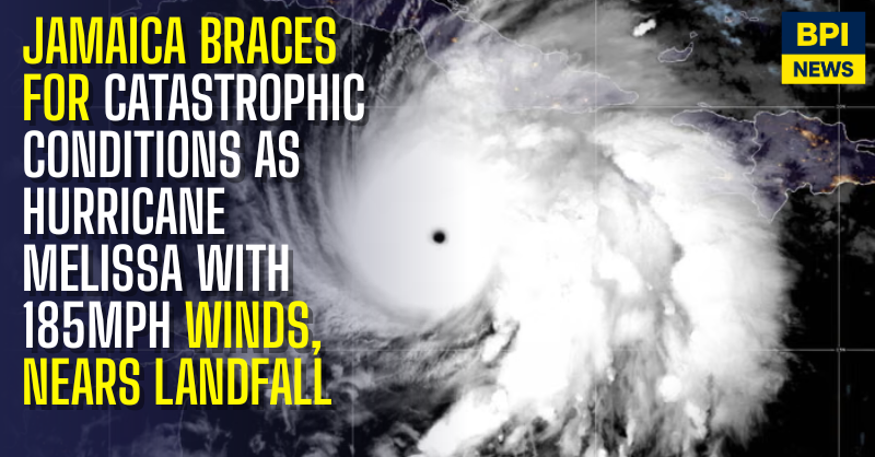
The northern edge of Hurricane Melissa’s eyewall is now closing in on Jamaica’s southern coast, signalling imminent landfall as the island braces for what meteorologists are calling the “storm of the century.”
The US National Hurricane Center (NHC) warned in its latest update that “life-threatening storm surge and damaging waves” are expected to mark Melissa’s arrival, with destructive winds, flash floods, and widespread devastation predicted across the island.
Melissa remains a Category 5 hurricane, sustaining winds of up to 185mph (295km/h) making it one of the strongest storms ever recorded in the Caribbean. The NHC says the hurricane’s core will reach Jamaica “within hours,” bringing catastrophic damage, particularly to the southern coast near Kingston.
Officials have confirmed that over 200,000 residents are already without power, and communications are deteriorating across several parishes. Emergency services continue to urge the public to remain indoors and avoid flooded areas, warning that conditions will deteriorate rapidly.
The World Meteorological Organization (WMO) has described Melissa as the “storm of the century for Jamaica,” while the International Federation of Red Cross and Red Crescent Societies estimates up to 1.5 million people could be affected.
Jamaica’s Prime Minister Andrew Holness has declared a national emergency, ordering the immediate evacuation of high-risk areas and stressing that “no infrastructure on the island can withstand a Category 5 hurricane.”
At the final briefing before the storm hits, Jamaica’s National Emergency Operation Centre (NEOC) outlined the following key points:
- The eye of Hurricane Melissa is expected to make landfall at midday local time (17:00 GMT) on the southern coast.
- The storm is expected to hit as a Category 5 hurricane, before weakening to Category 4 as it moves north-northeast across the island at 9mph (15km/h).
- As it exits Jamaica, Melissa could weaken further to Category 3 while heading toward Cuba’s eastern coast, where wind speeds of around 140mph (225km/h) are forecast at approximately 06:00 UK time tomorrow.
- Storm surges are expected to reach up to 13ft (4m) in bays and inlets — enough to submerge two-storey buildings.
- Widespread power outages have already hit major areas, though hospitals are operating on backup power.
- Emergency relief flights could begin as early as Thursday once weather conditions allow.
Minister of Local Government Desmond McKenzie warned citizens not to underestimate the storm, saying: “Don’t bet against Melissa. It’s a bet we can’t win.”
Meanwhile, torrential rain continues to lash Kingston and other southern regions, with rising floodwaters and falling debris reported. Meteorologists warn the hurricane’s slow movement could intensify flooding and landslides across mountainous terrain, further complicating rescue efforts.


